Subtropical Storm Alberto was a weird system. But we can discuss the science of “weird” another day. Today, on the official first day of the Atlantic hurricane season, I want to talk about jargon.
Meteorologists learn a truckload of new terms when they start studying the weather. And then we use those terms weekly if not daily. It’s surprisingly easy to forget what it was like when those words were confusing or unknown. Here, I’d like to translate some of the terminology thrown around related to hurricanes. (A hurricane has maximum sustained winds of at least 74 MPH.)
Let’s start with tropical cyclone, often shortened to TC. “Tropical cyclone” is the generic term for a tropical storm/hurricane that develops anywhere in the world. How do we know a storm is a tropical cyclone? Via three main criteria:
1) It spins
2) It has a closed circle of spinning
3) Thunderstorms hang out (and persist) near the center of the spinning
The spinning, or circulation, is important. All cyclones spin, and cyclones occur across the globe, but not all cyclones are tropical. (Here’s an example of a non-tropical cyclone over the Central U.S.) Also, the character of the circulation is important. If you read the fine print of National Hurricane Center (NHC) discussions, you may see text similar to “this storm has now developed a closed circulation and can be designated a tropical cyclone” when a storm receives a number or a name. This means the winds are spinning around the center on all sides, and once that happens, the storm is becoming more organized. Storms are more capable of strengthening when they have a closed circulation.
Finally, the thunderstorms. Thunderstorms are convective clouds: they form in response to rising air. This animated GIF of another NON-tropical cyclone shows temperature and, at the end, wind speed and direction. The strongest thunderstorms look coldest because the tops of the clouds reach high into the atmosphere, and the atmosphere gets colder as altitude increases. So the more yellow/orange/red a pixel is, the colder that cloud top is, and thus the higher it is. In the GIF, the coldest clouds are very far away from the center of the storm. This is one way we know a storm is NOT tropical. Tropical cyclones need those cold clouds–thunderstorms–to be close to the center. And those thunderstorms need to exist for an extended period of time, at least 12 hours. A single thunderstorm near the center isn’t enough to cause a spinning storm to be a tropical cyclone, but this pushes us into the dynamics of tropical cyclone development which is outside the scope of this post…
(One more thing: the word cyclone isn’t used for just anything that spins. A tornado is not a cyclone. Neither is a dust devil nor a waterspout. What’s the difference? Size. Cyclones are much larger than an individual tornado.)
Now for the word subtropical. It’s like “subpar.” Subtropical means a cyclone isn’t quite tropical. We use the term for cyclones that generally meet criteria #1 and #2 but not #3. Official definitions refer to subtropical cyclones as “hybrid” storms, having characteristics of both tropical and non-tropical cyclones.
Unfortunately, that’s confusing to any non-meteorologist. Why bother giving them names or issuing watches and warnings on subtropical cyclones? Because their effects aren’t much different from a tropical storm. They’re just as capable of producing storm surge, strong winds, and heavy rain. Those hazards can be deadly no matter the shape of the subtropical or tropical cyclone that causes them. It’s the NHC’s responsibility to monitor, forecast, and warn on tropical systems, and subtropical systems fit under that umbrella.
Let’s go back to the shape thing. Criterion #3 has the important caveat of thunderstorms being near the center. In a tropical storm (maximum winds between 39 and 73 MPH), the strongest winds are generally located near those thunderstorms shown in satellite images as the coldest cloud tops (often referred to as the deepest convection). So, in a tropical storm, those thunderstorms are near the center, and so are the strongest winds.
In a subtropical storm, the maximum wind criteria is the same (39-73 MPH), but where those winds are located isn’t. This means the center of the storm could hit land in the exact same place, but if it’s a subtropical storm, the strongest winds will be in a different spot compared to a tropical storm. This difference in the winds can affect the location of both storm surge and rainfall.
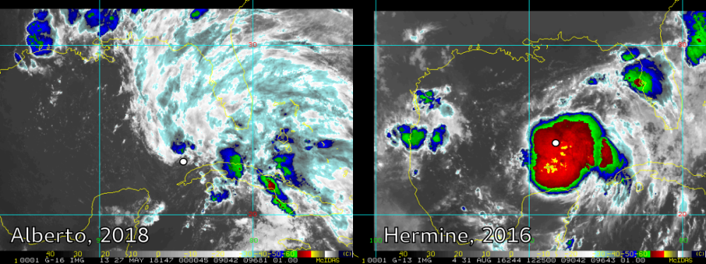
Here’s a satellite image comparison between Subtropical Storm Alberto and Tropical Storm Hermine. Cloud tops are much colder for Hermine than for Alberto, and the shape is also quite different:
Should we still label them differently for public communication purposes? Maybe not. It’s an ongoing debate in the scientific communication community. But the science behind the storms is different, and operational practices at the NHC tend to be led by science, not by communication. Efforts are being made to weave social science and psychology expertise into operational practices, but change can take a long time due to the testing and approval process required for official products. In the age of Twitter and other instant-access media, that change can feel glacially slow in coming.
One final note: for Alberto, the advisories eventually switched from the NHC to the Weather Prediction Center (WPC). This is because these two agencies serve different purposes, and the NHC isn’t responsible for continued monitoring of over land systems. However, the NHC webpage links to WPC advisories, so the flow of information isn’t interupted. Always pay attention to products from your local National Weather Service (NWS) office if you are in the path of any storm being monitored by the NHC.
Feel free to contact me with questions! In the meantime, I’ll leave you with a few acronym definitions and resource links:
NHC = National Hurricane Center, https://www.nhc.noaa.gov
WPC = Weather Prediction Center, http://www.wpc.ncep.noaa.gov
SSHWS = Saffir-Simpson Hurricane Wind Scale, https://www.nhc.noaa.gov/aboutsshws.php
